Off the Beaten Track Beaches
Off the Beaten Track Beaches
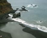
Playa Bollullo
Location: In the north of the island, in the Orotava Valley region.
Brief description: Gorgeous dark-coloured sand at the bottom of steep cliffs. Frothy waves hit the shore and spill on to the shore.
Services nearby: Just the one cool restaurant right on the beach, which gives this place a good edge in our opinion!
Good for: Getting away from it all, especially the tourists, lounging around with nothing much to do.
What we like: Large expanse of sand, plenty of space to spread out. Blissful isolation.
What we don’t like: The trek just to get to isolated Playa Bollullo is pretty long and a little shaky in places; make sure you travel light.
Driving directions: Head towards Icod de los Vinos. (If you're coming from the south take the TF-I north, then get onto the TF-5. The beach is signposted.
El Poris
Location: The village of EL Poris is on the Arico east coast
Services nearby: Not much! This is really off the beaten track.
Brief description: Volcanic sandy beach, waves can get a bit large and scary here, so watch out.
Good for: Getting away from it all.
What we like: Completely away from the hustle and bustle. Hardly any tourists. Peace and quiet, save the sound of the waves crashing on the shore.
What we don’t like: Nowhere to grab a bottle of water, so take provisions.
Driving directions: Drive up the TF-1 along the east coast and exit at El Poris.
El Puertito
Location: Just outside Armeñime
Brief Description: Lovely sandy bay in a small fishing hamlet with brightly coloured boats bobbing on the waters.
Services Nearby: Restaurants and cafes, particularly good fish restaurant close to the beach.
Good for: Dipping your toes in the sand on a beach that is pretty remote.
What we like: Quaint ambiance, traditional Tenerife feel to the place.
What we don’t like: Quite a few rocks makes getting into the water quite difficult.
Driving directions: Follow the sign for El Puertito from the TF-47 just outside Armeñime on the road west to Los Gigantes.
Masca
Location: At the end of Masca Barranco, Masca
Brief description: Black sand and shingle bay at the mouth of a long ravine and backed by high cliffs.
Services nearby: None. The nearest shops are a three hour hike or a ten minute boat ride away – bring a picnic.
Good for: Complete isolation disrupted only by the arrival of the occasional, exhausted hikers and the boat from Los Gigantes.
What we like: Endless Ocean views and complete silence save for the breaking of the waves.
What we don't like: It's a long way to carry the beach bag and the cliffs may be prone to rock fall, stay near the water.
Driving directions: Park in Masca and trek down the Barranco (3 hours) or park in Los Gigantes and take a boat trip.
El Socorro
Location: Off the coast road between Puerto de la Cruz and San Juan de la Rambla.
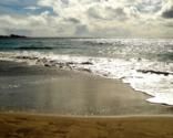
Brief description: Long, sandy volcanic beach at the foot of the headland which is popular with the young, families and surfers.
Services nearby: Excellent cafe/restaurant on the beach with good fish and tapas and a dining room jutting out over the sea.
Good for: Stunning location and a lively scene during surfing competitions.
What we like: Loads of free parking and the feeling that you've discovered a secret beach.
What we don't like: The spring tides have been known to nick the beach and not give it back – great for surfers, not so good for paddlers.
Driving directions: On the north coast TF42 heading from Puerto de la Cruz to Icod, watch for the sign just beyond Mirador de San Pedro a couple of kilometres outside Puerto.
Mesa Del Mar
Location: On the coast of Tacoronte.
Brief description: Large sheltered, dark sandy bay hidden away on a stretch of coastline that is completely off the tourist radar.
Services nearby: A cafeteria at the back of the beach and a restaurant in the camp site behind.
Good for: Getting way off the tourist track.
What we like: Oodles of space to spread out and calm waters for swimming.
What we don't like: The ugly high rise buildings on the other side of the tunnel, luckily you can't see them from the beach.
Driving directions: Leave the TF5 at Exit 19 and follow the TF16 Tacoronte – Tejina road through Tacoronte. Take the Mesa del Mar road down to the coast, park in the village and walk through the tunnel.
Playa Las Arenas
Location: Alongside Buenavista Golf Course, Buenavista
Brief description: Long, thin black sand and pebble cove with rock pools to explore and good body-boarding waves.
Services nearby: Seafood restaurant festooned with fishing nets, and a kiosk selling snacks, ices and cold drinks.
Good for: Lovely coastal walk alongside and that 'away from it all' feeling.
What we like: Masses of free parking right alongside.
What we don't like: The sandy bits are at a premium.
Driving directions: From Buenavista in the north west corner of the island, follow the signs to the golf course and then to the beach.